Overview
Research Focus
Facilities
Select Publications
Projects
Research Staff
Overview
Remote sensing is a multidisciplinary technique cum methodology in which spatially resolved images and spectra are collected from satellite, aircraft or remote stations, and used to identify and map surficial features. There are two types of remote sensing sensors/instruments—passive and active. Passive sensors/instruments detect natural energy that is reflected or emitted from target object. Active sensors/instruments provide their own energy (electromagnetic radiation) for illumination of the object or scene that is being observed. They send a pulse of energy from the sensor to the object and then receive the radiation that is reflected or backscattered from that object.
Microwave remote sensing uses electromagnetic radiation (active sensors) with a wavelength between 1 cm and 1 m as a measurement tool. Microwaves exhibit the important property of penetrating clouds, fog, and possible ash due to their larger wavelengths when compared to IR and visible radiation. This important property makes microwave remote sensing virtually suitable to work independent of sun light availability and in any weather condition.
Research Focus
The objectives of the researchers working in the Remote Sensing lab are focused on studying innovative methods and techniques for the processing & interpretation of remotely sensed data in the areas of Disaster management, Cryosphere and Agriculture. The most commonly used microwave imaging sensor is the Synthetic Aperture Radar (SAR). SAR is a radar system capable of providing high-resolution microwave images. They have unique characteristics compared to regular optical images acquired in the visible or infrared bands; for this reason, radar and optical data can be complementary, as they carry on a different informative contribution. Table shows the frequency bands used in microwave remote sensing.
Table – Microwave radio bands
| Band | Frequency range (G Hz) |
| L | 1-2 |
| S | 2-4 |
| C | 4-8 |
| X | 8-12 |
| Ku | 12-18 |
| K | 18-27 |
| Ka | 27-40 |
| V | 40-75 |
| W | 75-110 |
| Mm | 110-300 |
| Sub mm | >300 |
In microwave remote sensing, the S-band wavelength (3.1–3.3 GHz) lies between the longer L-band (1–2 GHz) & the shorter C-band (5–6GHz) and has been insufficiently studied for disaster management applications due to limited data availability. Hence the lab, envisages on potential assessment of S-band SAR and evaluation of airborne L & S band SAR for disaster management applications. The proposed work also encompasses studying the ability of using various SAR datasets in disaster damage identification through image classification. Airborne L & S band datasets will be provided by ISRO for the flood prone regions (as shown in figure) in the country under the NISAR mission (NASA-ISRO-SAR). This dataset will be processed in the lab for inundation mapping, damage assessment, etc. The lab is also working in crop monitoring and Cryosphere related applications using SAR datasets. The figure shows NISAR mission image of Antarctic ice.
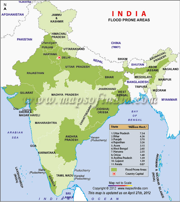
Top Ten Flood Prone Areas In India

Antarctic Ice – NISAR mission image
GNSS
The lab is also engaged in GNSS related research activities namely IRNSS Navigation Receiver Field Trial and Data Collection
IRNSS is India’s own regional navigation system renamed as Navigation with Indian constellation (NAVIC). It is designed to provide accurate position information service to Indian users and the coverage area extends up to 1500 km from the boundary of India, which is its primary service area. The IRNSS System is expected to provide a position accuracy of better than 20 m in the primary service area. IRNSS provides two types of services namely Restricted Service (RS), which is encrypted& available only for authorized users with high precision and Standard Positioning Service (SPS) to all users. Presently there are seven satellites in the constellation placed above 36,000 km from the surface of earth. Three satellites are placed in geostationary orbit at 32.5° East, 83° East, and 131.5° East longitude with fixed position. The other four satellites are in geosynchronous orbit, where each set of satellites will cross the equator at 55° and 111.75° East. The IRNSS satellite signals are available at L5 band (1176.45 MHz) and S band (2492.028 MHz) microwave frequencies.
IRNSS receiver had been installed at CIIRC- Jyothy Institute of Technology by SAC-ISRO, Ahmadabad to enhance the receiver position accuracy through field trial and data collection under different environments. The research team is carrying out basic research and experiments with the IRNSS receiver data collected at this lab. The activities include:
- Performance evaluation of IRNSS user receiver
- Interference study for IRNSS user receiver
- Development of marine navigation application for fishermen using IRNSS user receiver
- Position accuracy analysis using Hadoop
- IRNSS receiver related android applications

IRNSS receiver system, antenna and sky plot
Circuit simulation for design of modern VLSI circuits
Not so long ago, researches were focused on developing portable applications in pursuit of high performance, thus increasing system complexity. Natural fallout of this process has been abridged battery life and long term reliability issues. Analysis of such systems, points to increased power consumption as the main factor. These realizations spurred interest in the area of low power design consequently creating a new field of electronics. Therefore along with area and speed, power consumption is an important criterion in measuring system performance. The benefit of utilizing a combination of low-power components in conjunction with low-power design methodologies is more important now than ever before. Low power requirements continue to grow extensively as components become battery-powered, smaller and require more functionality. In order to realize ultra low power SoC applications, circuits should be operated with low power dissipating gates. To support the ever-changing needs of current and emerging applications, the research team is also working in the design of low power VLSI and reversible logic circuits. The team has designed and simulated various low power dissipating gates and their applications using VLSI EDA tools such as Synopsys, Cadence and Mentor Graphics.
Facilities
- VLSI Tools, IRNSS Receiver, Work Stations
- Sentinel Toolbox
- QGIS Semi-Automatic Classification Plugin
- Geographic Resources, Analysis & Support System
- PoISAR PRO
- GNU Octave
Select Publications
Position Error Analysis of IRNSS Data Using Big Data Analytics’. Geetha Priya M, Kiran Kumar D.C. Springer- Communications in Computer and Information Science(Accepted).
Radar and its applications. Geetha Priya M. et al, International Journal of Control theory & applications(2017) 10(3): 1-9.
A new low power 4T based three input universal gate for high speed applications. Geetha Priya M. et al., Springer-Lecture Notes in Networks and Systems (Accepted).
A Novel Reversible n Bit Counter for Low power Quantum computing. Geetha Priya M. et al, International Journal of Control theory and applications(2017) 10(3): 11-20.
Plant-Based completely biodegradable printed circuit boards. Vijay Kumar Guna, Geethapriya M., Manikandan Ilangovan, Sharon Olivera, Venkatesh Krishna, Narendra reddy et al, IEEE Transactions on Electron Devices (2016)63 (12):4893 – 4898.
Eigenvector based wideband spectrum sensing with sub- nyquist sampling for cognitive radio. V D Inglae et al., Journal of Scientific & Industrial Research (2017) 76: 535-539.
Projects
IRNSS navigation receiver field trial and data collection- SAC-ISRO, DOS
Waste to Wealth approach: development of completely biodegradable printed circuit boards using proteins and natural fiber based composites-VGST
Evaluation of Airborne L and S-band SAR for Disaster Damage Identification-NISAR (NASA-ISRO)
Sensitive white space detection by spectrum sensing for cognitive radio application- SSPS
Development of marine navigation application for fishermen using IRNSS user receiver- SSPS
Research Staff


Chandrasekhar K having obtained his Ph D from VTU researches in the domain of Signal Processing & Communication and works as an Professor. In his last assignment he headed the M.Tech programme in DSP & RF Communication streams, at the Centre for Emerging Technologies of Jain University. He has contributed in building various new knowledge base to the domain on subjects like Auto-correlation matrix implementation in LabVIEW™, Monte Carlo simulation and its importance in data analysis using LabVIEW™. Prior to that he was the Head of the Department of Telecommunication Engineering at KSIT, Bangalore and was instrumental in building up the department, and the facilities, ground up. He has been in the academic field for 25 years. He has many publications in journals and has presented at various conferences and workshops. His Extracurricular activities include table tennis, Cricket, Football and swimming.
Email Id: chandra.k@ciirc.jyothyit.ac.in

Deepak Ingale has a Master’s in VLSI and Embedded Systems. He has over seven years of academic experience and two years of industrial experience with Wipro Technologies. He has worked as an Assistant Professor at the Centre for Emerging Technologies at Jain University and had been involved in setting up a DSP Laboratory, where he actively taught M.Tech students. He has also designed and delivered value added programs on LABVIEW programming, PCB Designing and building embedded systems for hobby using ARDUINO. He had been a Project Engineer at Wipro Technologies and was instrumental in component selection, board re-design (PCB), setting up & conducting First Piece Evaluation (FPE) of various telecom switches and related activities. He has been involved in designing the electronics part of the nano-biosensor for ammonia detection and used in micro air vehicles, funded project by NP-MICAV (DST-DRDO). He has published several papers in various national and international journals and is working as an Assistant Professor.
Email Id: deepak.vi@ciirc.jyothyit.ac.in
TGS Moorthy with a Ph.D In Electronics from the University of Sagar has had the distinction of being the founding Dean of Sikkim- Manipal University. He has also been nominated to various academic bodies of different universities in the state and has a rich heritage experience of 40 years to his credit. In erstwhile capacities he steered MIT, Manipal in various capacities. His interest includes satellite communication and microwave engineering. He is currently the Advisor and Visiting Professor to the Centre.
Email Id: drtgsm@gmail.com
 Gomathi is basically a civil engineer by profession with masters in Remote sensing. She is the alumni of Anna University, Guindy, Chennai. She has 3 years of experience working as an Assistant Professor in an Engineering college. She is working as a Research Fellow in CIIRC under NISAR project (NASA-ISRO synthetic Aperture Radar) for Natural Disaster related studies funded by SAC-ISRO. She has two publications in international journal to her credit. She is also pursuing her Ph.D under VTU. Her area of interest is microwave remote sensing and Disaster studies using satellite imagery.
 Nagajothi is a Post graduate in remote sensing and Under Graduate in Civil Engineering from Anna University, Tamil Nadu. She had completed two projects namely, Flood Monitoring for Chennai using GIS and Remote sensing under the guidance of Public Works Department, and Himalayan displacement analysis using Interferometry under National Remote Sensing Center, Hyderabad. Currently, she is working as a Research Fellow in CIIRC under HICOM project funded by NCOAR, Ministry of Earth Sciences. Her research work includes snow cover, snow line and snow depth estimation of Western Himalayas and Interferometry techniques.
Email: jovenkat67@gmail.com