Overview
Remote Sensing is a multidisciplinary technique cum methodology in which spatially resolved images and spectra are collected from satellite, aircraft or remote stations, and used to identify and map surficial features. There are two types of remote sensing sensors/instruments—passive and active. Passive sensors/instruments detect natural energy that is reflected or emitted from target object. Active sensors/instruments provide their own energy (electromagnetic radiation) for illumination of the object or scene that is being observed. They send a pulse of energy from the sensor to the object and then receive the radiation that is reflected or backscattered from that object.
Microwave remote sensing uses electromagnetic radiation (active sensors) with a wavelength between 1 cm and 1 m as a measurement tool. Microwaves exhibit the important property of penetrating clouds, fog, and possible ash due to their larger wavelengths when compared to IR and visible radiation. This important property makes microwave remote sensing virtually suitable to work independent of sun light availability and in any weather condition.


The objectives of the researchers working in the Remote Sensing lab are focused on studying innovative methods and techniques for the processing & interpretation of remotely sensed data in the areas of Disaster management, Agriculture, Polar Cryosphere, Climate Change, GIS & GNSS, Mapping and Digitization. The most commonly used microwave imaging sensor is the Synthetic Aperture Radar (SAR). SAR is a radar system capable of providing high-resolution microwave images. They have unique characteristics compared to regular optical images acquired in the visible or infrared bands; for this reason, radar and optical data can be complementary, as they carry on a different informative contribution.
Why Do We Research the Cryosphere?
The entire climate system relies heavily on snow and ice. The cryosphere keeps Earth from being too heated by acting as a highly reflecting barrier. Open water or bare land reflect more sunlight than snow and ice. As a result, the presence or absence of snow and ice influences heating and cooling over the Earth’s surface, affecting the planet’s overall energy balance. Air temperatures, sea levels, ocean currents, and storm patterns are all affected by changes in snow and ice cover across the planet.

GNSS – IRNSS / “NavIC” (Navigation with Indian Constellation)
The lab is also engaged in GNSS related research activities namely IRNSS Navigation Receiver Field Trial and Data Collection. IRNSS is India’s own regional navigation system renamed as Navigation with Indian constellation (NAVIC). It is designed to provide accurate position information service to Indian users and the coverage area extends up to 1500 km from the boundary of India, which is its primary service area. The IRNSS System is expected to provide a position accuracy of better than 20 m in the primary service area. IRNSS provides two types of services namely Restricted Service (RS), which is encrypted& available only for authorized users with high precision and Standard Positioning Service (SPS) to all users. Presently there are seven satellites in the constellation placed above 36,000 km from the surface of earth. Three satellites are placed in geostationary orbit at 32.5° East, 83° East, and 131.5° East longitude with fixed position. The other four satellites are in geosynchronous orbit, where each set of satellites will cross the equator at 55° and 111.75° East. The IRNSS satellite signals are available at L5 band (1176.45 MHz) and S band (2492.028 MHz) microwave frequencies.
IRNSS receiver had been installed at CIIRC®– Jyothy Institute of Technology by SAC-ISRO, Ahmadabad to enhance the receiver position accuracy through field trial and data collection under different environments. The research team is carrying out basic research and experiments with the IRNSS receiver data collected at this lab. The activities include:
- Performance evaluation of IRNSS user receiver
- Interference study for IRNSS user receiver
- Development of marine navigation application for fishermen using IRNSS user receiver
- Position accuracy analysis using Hadoop
- IRNSS receiver related android applications

GNSS – DGPS
With the GPS method the position can be determined with an accuracy of several meters. This is usually accurate enough for recreational navigation, but for certain applications higher order accuracy is needed. A method to achieve this is differential mode GPS. The DGPS system involves installing a reference base with known coordinates. This real-time receiver carries out distance measurements between the receiver and each of the visible GNSS satellites. The measured distances include many errors that degrade the positioning accuracy. However, the base, of which we have the actual coordinates as well as those of the satellites, can calculate the theoretical distance without error. The difference between the theoretical distance and that measured for each satellite gives the global measurement error that will be used to correct the station of unknown coordinates of which we seek to determine the position. The correction can be done using post-processing techniques or in real time (GSM or radio link with the base). For real time corrections, we speak of “real time kinematic” GPS or Real Time Kinematic (RTK). It is these local correction systems that we call Local Area Augmentation System (LBAS). Under normal conditions, the accuracy of DGPS measurements is in the order of millimeters. This lab has an higher end DGPS system procured (SP80 model) from Spectra Geospatial Inc.


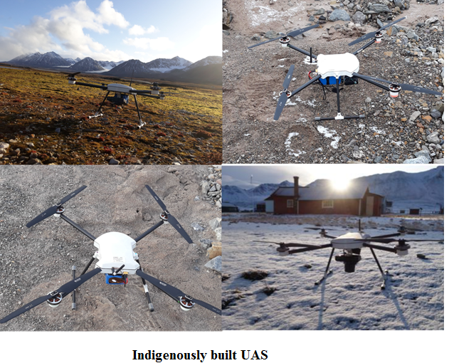
Unmanned Air Systems (UAS)
This lab is also equipped with wide variety of UAS which includes self designed prototypes and ready to fly systems . These UAS are used for GIS mapping and other educational R & D purposes. The payloads include RGB, thermal , NIR and atmospheric sensors. The UAS are all registered under DGCA with UIN and with licensed piloting.
Some of the most common commercial applications and uses for UAV Drones are:
- Aerial Photography & Videography
- Real estate photography
- Mapping & Surveying
- Asset Inspection
- Payload carrying
- Agriculture
- Bird Control
- Crop spraying
- Crop monitoring
- Multispectral/thermal/NIR cameras
- Live streaming events
- Roof inspections
- Emergency Response
- Search and Rescue
- Marine Rescue
- Disaster zone mapping
- Disaster Relief
- Forenzics
- Mining
- Firefighting
- Monitoring Poachers
- Insurance
- Aviation
- Meterology
- Product Delivery
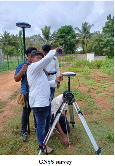
FIELD VALIDATION
Remote sensing based measurements become complete only when the results are validated with the field datasets. Our team has actively carried out fieldworks related to Glacier, ice and snow at Himalayas, Karakoram and Arctic region using GNSS/DGPS, Unmanned Air Vehicles, Snow parameter measurement tools, etc. Field work has also been carried out at other locations for various applications and projects.


- Geetha Priya M., Narayan, V. &D evaraj , S. (2021) “Spatial analysis of supraglacial debris cover in Svalbard, Arctic Region—a decadal study”,. Environ Sci Pollut Res . https://doi.org/10.1007/s11356-020-12282-x, IF:4.01
- Sivaranjani Sivalingam, Geetha Priya M, Krishnaveni Dhulipala, Anil Vishnupant Kulkarni & Ankur Pandit (2021), ” Essential Study of Karakoram Glacier Velocity Products Extracted Using Various Techniques”, Geocarto International, DOI: 1080/10106049.2021.1974954, IF:4.889
- Sivaranjani Sivalingam, Geetha Priya M, Krishnaveni Dhulipala, Anil Vishnupant Kulkarni & Suresh Devaraj (2021), “Temporal fluctuations of Siachen glacier velocity: a repeat pass sar interferometry based approach”, Geocarto International, DOI: 1080/10106049.2021.1899306, IF:4.889
- M Geetha Priya, K. Venkatesh, L. Shivanna, and S. Devaraj (2020), “Detecting short-term surface melt over VestreBroggerbreen, Arctic glacier using indigenously developed unmanned air vehicles,” Geocarto International, DOI: 10.1080/10106049.2020.1849416, IF:4.889
- Geetha Priya M, Varshini N,Chandhana G, Deeksha G, Supriya K,Krishnaveni D (2021), “Study on Snowmelt and Algal Growth in the Antarctic Peninsula using Spatial Approach”, Current Science, Vol. 120, No.5, pp. 932-936. IF:1.1
Existing Facilities (Computing Resource, Software, Equipment, etc.):
- Computing Resource – Remote sensing lab with high computing workstations up to 25nos and with all necessary survey equipments.
- Software – HEC-RAS, MATLAB, QGIS, SNAP, GMTSAR, OCTAVE, MIDAS, RAT, R, Google COLAB, ENVI, ERDAS IMAGINE, ARCMAP.
- Equipment – SP80 DGPS, Trimble 100 Handheld GPS, Total station, laser ranger, UAS, snow measurements kit, etc.


- Retrieval of ice velocity using Interferometry techniques to understand the ice dynamics and glacier stored water of Karakoram glaciers – under NIMSHE, DST, GOI.
- Monitoring of Surface Melt on selected glaciers of Spitsbergen, Svalbard Using UAV Surveys – under Indian Arctic Program, NCAOR- Ministry of Earth Sciences, GOI.
- Snow cover, snow depth and snowline studies in Himalayan basins – under HiCOM initiative, NCAOR- Ministry of Earth Sciences, GOI.
- Evaluation of airborne L and S band SAR for disaster damage identification- under NISAR mission , SAC-ISRO, Ahmedabad.
- Integrated studies of Himalayan Cryosphere (ISHC) using space based inputs, SAC-ISRO, Ahmedabad.
- IRNSS navigation receiver field trial and data collection, SAC-ISRO, Ahmedabad.
- Waste to wealth approach: development of completely biodegradable PCBs using proteins and natural fiber based composites- under SMYSR, VGST-KSCST.

Geetha Priya M
Geetha Priya an alumni of Anna University obtained her Bachelors (ECE), Masters (M.E.) and Doctoral degree from Anna University, Chennai, in the faculty of Information & Communication Engineering. She is currently working as Professor at the Centre for Incubation Innovation Research and Consultancy (CIIRC), Jyothy Institute of Technology, Bangalore Research Centre of the Sri Sharadha Peetham, Sringeri.
Her areas of research include Signal processing, Optical & microwave Remote sensing, GIS and Polar Cryosphere. She has more than 17 years of experience in different domains of academics and research with numerous research publications in peer reviewed high impact journals to her credit besides 2 products and 3 patent filings.
Dr. Geetha currently has completed sponsored projects from Indian Space research Organization (ISRO), Department of Science & Technology (DST), Ministry of Earth Sciences (MOES), Vision Group of Science & Technology (VGST). Currently, she is actively carrying out research in the area of Remote Sensing which includes Polar Cryosphere and Disaster Management studies.
Dr. Geetha was a member of the Indian Scientific Expedition to the Arctic (North Pole)- Summer-2019 logistically funded by NCPOR, MOES, GoI and became the first Indian team to fly UAVs (Drones) in the north pole to undertake remote sensing activity. The other members of the team included scientists from JNU, NCPOR, NIO, GSI and IISER (K). She has also extensively undertaken field visits in the Himalayas and Karakoram for ground truth verification. Besides she is also a trained mountaineer having been trained at the Himalayan Mountaineering Institute and a trained & DGCA licensed UAV pilot.
Her other activities include supervision of doctoral scholars, post graduate and under graduate student projects. She is a life member of various professional bodies such as IETE, IAENG, ISG, IEI and has been a reviewer for various journals and conferences.

Sivaranjani S
Sivaranjani is a Postgraduate in Remote Sensing and Under Graduate in Civil Engineering from Anna University, Tamil Nadu. She worked on Wind Speed mapping of Tamilnadu using GIS and remote sensing techniques and in Offshore wind Energy Projects as an intern supported by NIWE, Chennai. Currently, she is working as a Research Fellow in CIIRC under DST project entitled “Retrieval of ice velocity using Interferometry techniques to understand the ice dynamics and glacier stored water of Karakoram glaciers”. This work is funded by SPLICE-CCP, Government of India, under National Network Program on Himalayan Cryosphere. Her research work includes velocity, ice thickness and volume estimation of Karakoram glaciers based on the satellite data. She has two publications in international journal to her credit.